Saturday, November 18, 2006

Rivers in Art

I was in Washington DC this week at meetings with my colleagues with the Hydropower Reform Coalition who work to represent the public interest in the regulation of hydropower facilities for the benefit of fish, wildlife, people on our nation's rivers. It was a good week as I met with a couple of the new Commissioners over at the Federal Energy Regulatory Commission and also had a chance to sit down with Senator Murray. While the policy work was fun, it was a real pleasure to have a bit of time between meetings to view some of my favorite paintings on display in the museums. I have always been a real fan of 19th century American Painting, and in particular the Hudson River School, since my art history classes in high school and our trips to view Thomas Cole's Voyage of Life on display at Munson-Williams-Proctor Institute in Utica, NY just a short drive from the town where I grew up.

The art of this period parallels the exploration and settlement of the American Frontier and explores the wilderness landscape in a sharp departure from European art of the same period. At the same time that the artists of the Hudson River School were interpreting the rivers, forests, and mountains of the nation poets such as William Cullen Bryant and writers such as Henry David Thoraeu and John Muir were beginning to explore themes that would form the foundation for an American concept of Wilderness, a concept that was later refined by individuals such as Aldo Leopold and Bob Marshall and ultimately tackled by Congress with the passage of the Wilderness Act.


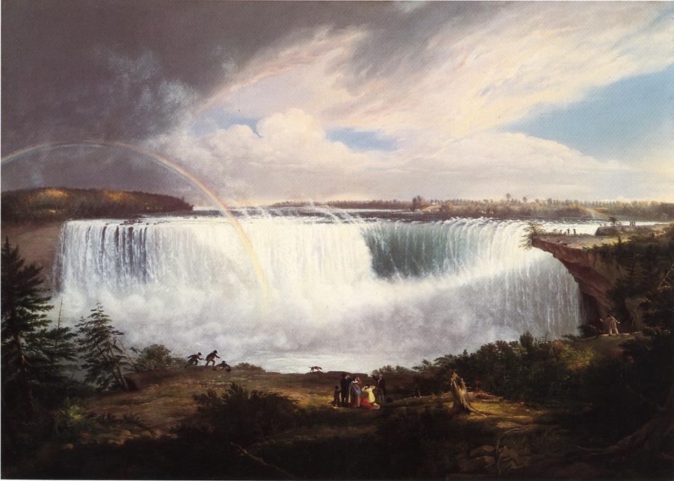
I found this painting of Niagara Falls painted by Alvan Fisher in 1820 tucked away in a hallway in the Smithsonian Museum of American Art. It's an interesting painting representing one of the early illustrations of a scene that was soon to become a symbol of the epic scale of America's scenic wonders and natural beauty.


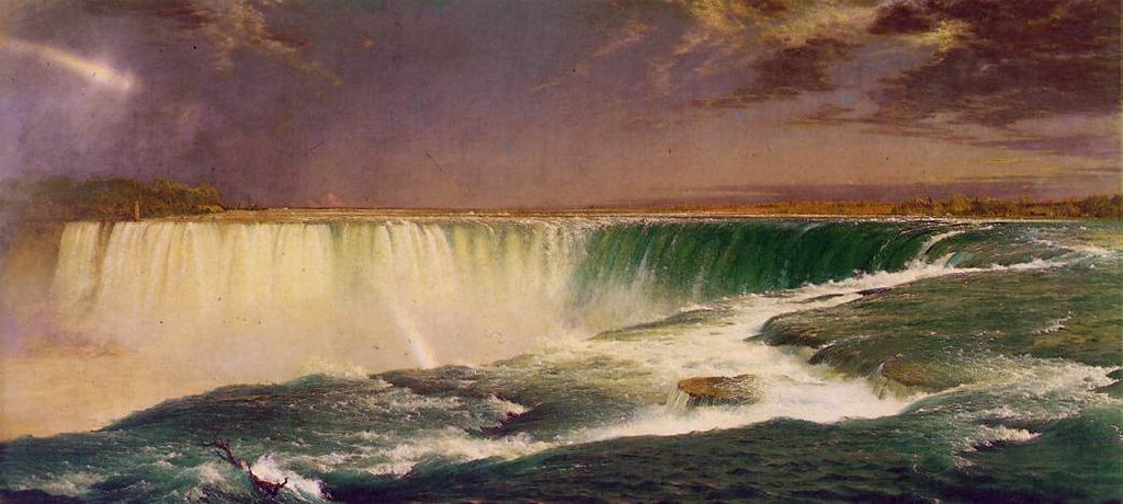
In a departure from the more traditional views looking upstream at the falls that were painted by Fisher and others, Frederic Church took a dramatic approach by placing the vantage point right at the lip of Horseshoe Falls on the Canadian side in his 1857 painting of Niagara Falls. Unfortunately this painting, owned by the Corcorran gallery, was off on tour so I did not actually get to see it in person. I love this painting because it is my favorite depiction of the power of water and really draws you in with the energy you experience at the lip of a big waterfall.


The Jolly Flatboatmen was painted in 1846 and hangs over in the National Gallery and has always been one of my favorite paintings. The thing I really enjoy about this painting is the connection between people and the river. Our transportation system is dominated by highways, trains, and air transport but at one time rivers were the primary highway of commerce.


I have always had this focus on American landscape paintings and have not spent much time exploring what the European artists were up to at the time, but while I was in town the National Gallery had a great show of John Contstable's paintings of the Stour River in England. These are the 6 foot landscapes and the White Horse which was in the show and seen above was painted in 1819. What's interesting about these paintings is the contrast with the American experience that we see in the paintings of the Hudson River School that were to come a few years later. The Stour River is depicted as a working river with tow paths, locks, mills, and dams. The show was fascinating because it paired up the finished landscape paintings with full size oil sketches and smaller drawings that Constable made in develop the concept for a painting. Now spread throughout museums around the world the paintings and studies were all brought together in one show.


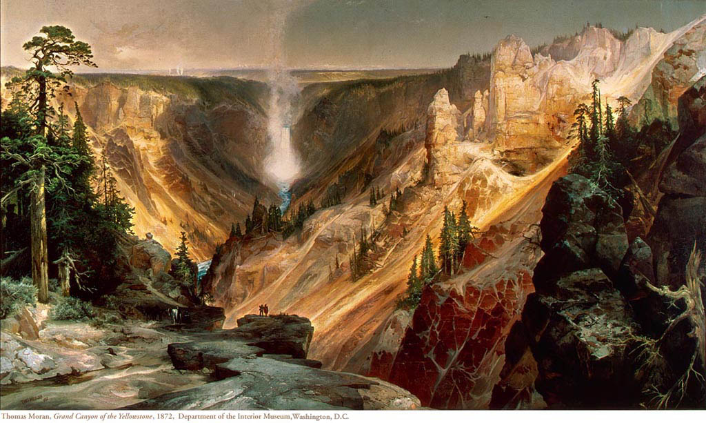
Turning back to the American experience and an appreciation for the scenic wonders of the continent, one is drawn to the paintings of Thomas Moran. Moran is well known for his spectacular images of Yellowstone. His watercolors along with the photographs of William Henry Jackson played a pivotal role in the creation of America's first National Park. As no members of Congress had been to Yellowstone, Ferdinand Hayden, who led the 1871 government survey to Yellowstone, brought the visual testimony to Capitol Hill. The approach proved effective and the Park was established in 1872. Shortly thereafter Congress appropriated $10,000 for the purchase of Moran's painting, The Grand Canyon of the Yellowstone. The river remains the longest undammed river in the Western United States at 671 miles from its source to the Missouri River.


The painting now hangs in the Renwick Museum just a couple blocks from the Whitehouse along with two other large Moran landscapes and framed by dozens of George Catlin paintings of Native Americans on the great plains. It's a neat gallery set up in the style of a 19th century museum.


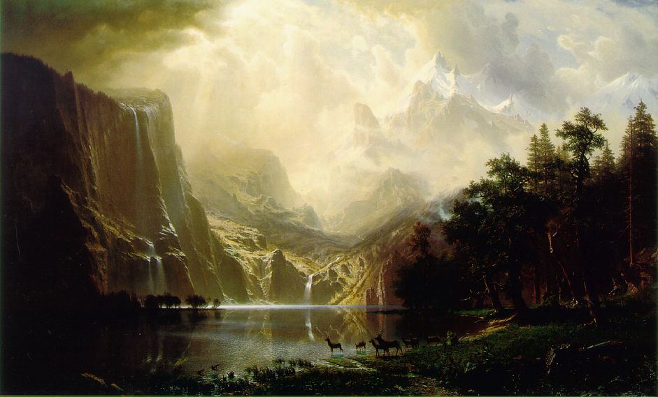
Albert Bierdstadt painted some of the most famous images of the Sierras from the 19th century as he provided a visual representation of a landscape that John Muir was writing about.


Bierstadt's painting is wonderfully displayed in an alcove in the Smithsonian American Art Museum.


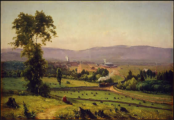
As the 19th century passed into the 20th century we would see more art that would explore themes of taming the wilderness frontier. While it does not depict a river, I have always enjoyed Lackawanna Valley painted by George Inness in 1855 and on view in the National Gallery. It is one of the early paintings to introduce industrial progress into the American landscape. A train transports coal through the valley and the fresh-cut tree stumps show a landscape that has been recently cleared.


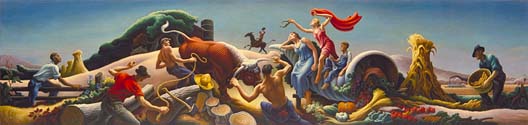
Thomas Hart Benton s 1947 mural Achelous and Hercules, in the National Museum of American Art, portrays the taming of the land and its bounty, and specifically the Missouri River that the Army Corps of Engineers was busy harnessing for the "benefit" of society. In Greek mythology Achelous is the diety of rivers and although he would assume different forms he is typically depicted as a bull. Hercules broke off one of his horns and it became the Cornucopia. The Army Corps of Engineers was working to harness the "wild river" that tore off like a bull across the floodplain each spring. Only now are we beginning to consider the ecosystem services naturally flowing rivers provide, and the expense incurred in trying to control them (see John McPhee's The Control of Nature).

So that was the trip to DC. I could write about all our meetings that consumed the bulk of my time but it's not often I get a chance to see these great paintings.

Wednesday, November 08, 2006

Rivers in Flood

Rivers throughout the region have been at record levels following intense rains on Monday November 6, 2006. Here are some photos from the Snoqualmie River drainage the following morning with some reference photos at lower flows. This is clearly a channel-forming flood event.

The Middle Fork Snoqualmie at 22,000 cfs.


Island Drop Rapid on the Middle Fork Snoqualmie at 22,000 cfs (left) and at more moderate flows of about 1500 cfs (right).


Looking upstream at Island Drop Rapid at 22,000 cfs on the Middle Fork Snoqualmie.


Snoqualmie Falls at 47,000 cfs.


Snoqualmie Falls at more moderate flows.

Monday, November 06, 2006

Beyond the Guidebook

Exploring the Upper Sultan Drainage.

One of the great things about living in the Pacific Northwest is the thousands of river miles available for exploration and adventure. While I have been a lifelong paddler, that's just a means to the end of my real passion which is exploring rivers.

While the classics of the Cascades have probably been discovered there are still some nuggets to be found here and there. Over the past few years groups have explored upstream reaches of Canyon Creek on the Stillaguamish, Lightning Creek in North Cascades National Park, North Fork Tolt, and the North Fork Skokomish in Olympic National Park. These explorers have returned with reports of sections of rivers few have seen. Over the past couple years I have been a stakeholder in negotiations over the future management of the Sultan River which provides water and power for Snohomish County. Andy Bridge, who designs paddles for Werner Paddles, lives on the river and has been the primary local volunteer engaged in this effort. While our focus has been on the incredibly scenic gorge reach below Culmback Dam, Andy has been exploring the upper reaches of the watershed where steep creeks emerge from some of the most rugged terrain in the Cascades. So when Andy called me this past weekend to say levels looked good for an exploratory on Elk Creek, I knew it was time to dust off the creeking gear and call a start to the fall boating season.

Shuttle logistics are easy on Elk Creek: you hike up as far as you want to paddle. The road ends at the bridge across Elk Creek and the wilderness of the Upper Sultan begins. This is not true Wilderness as the drainage shows past evidence of harvest activity, but as you step off onto the old road up the valley that is being reclaimed by the forest you quickly realize you are entering a region where few individuals pass. On the borders of the proposed Wild Sky Wilderness this is rugged terrain without maintained trails but here you find opportunities for exploration less than 2 hours from downtown Seattle. Remnants of old-growth remain and high bedrock walls tower overhead. Thick tapestries of moss hanging down from trees along the trail were clear evidence of the more than 15' of rain this valley sees.

We hiked for about two hours up the old road bed and over a couple of creeks where concrete crossings provided evidence of a past era. As the road further degraded we hiked down the hill to the creek. When we arrived we found low water and were immediately faced with a large log jam to portage. As we shouldered our boats and began hiking downstream, we were left wondering if we had put in too high.

Andy Bridge at the put-in for Elk Creek.


Our situation quickly improved though as small tributaries poured in from the sides and the creek grew in volume. We had a couple more wood portages interspersed with some fun class IV. Impressive scenery bordered the creek as mountains disappeared up into the clouds and captured the moisture that fueled waterfalls hundreds of feet high.

Elk Creek with Red Mountain towering up into the clouds.


After a couple more log limbo moves we started to really hit a groove as the creek began to weave its way through boulder gardens and dropped over a couple of ledges. We portaged part of a three tiered ledge although it did appear there was a line. We then came up to a rapid with a large boulder on river left. It looked like a fun drop but a few strategically placed logs, including one pointing straight out into the current, made the line just a little too tight. We opted to walk it but put in below to run some of the best rapids of the day.

Looking downstream into a fun class IV stretch.


We were crusing along when we came to a class 3 rapid that disappeared around the corner. It looked good but we could not see our next eddy so I hopped out for a look. I quickly realized that the river plunged into a challenging class V gorge. The entire river, squeezed between narrow bedrock walls, churned violently in a big hole at the entrance. Downstream we could see at least 5 more challenging holes. It was probably not unrunnable but it looked like potential trouble at this level so we began the difficult scramble along river left. From the bottom of the gorge we encountered great continuous whitewater including one of the best stretches of the run which begins upstream around the corner above the bridge and finishes off just below the bridge.

Looking upstream from the Elk Creek Bridge near the take-out.


After passing under the bridge we continued on downstream as the river tapered off to class III and once we hit our first log portage we decided to take-out and hike back up to the road.

Was Elk Creek a new classic? Not quite, but it was certainly a fun way to spend the day and great way to explore a hidden river valley that few people have seen and probably nobody else has paddled. Sections were reminiscent of the Foss or the Rapid in the Skykomish drainage but this run is shorter and with the hike in the run is more work to get to. Levels were about right for an exploratory (the nearby South Fork Sultan was at 300-400 cfs). It was a little low for some of the rapids but just right for others.

Labels: ,

Friday, November 03, 2006

Condit Dam: What's Next?

Klickitat PUD explores ownership of the dam but financial risks are significant.

On September 22, 1999 PacifiCorp signed an agreement to remove Condit Dam on the White Salmon River. The agreement represents the culmination of two years of negotiations between resource managers and over a dozen separate stakeholder groups who enjoy the White Salmon River. The agreement calls for removal of the 125-foot-tall concrete dam that since 1913 has diverted water from the natural channel obstructing downstream navigation and blocking upstream fish passage. While the removal process continues to move forward and is scheduled for fall 2008, Klickitat County PUD recently raised the possibility that they would acquire the dam and take over operation of the hydropower project.

In an October 26th editorial appearing in the White Salmon Enterprise, Klickitat Public Utility District Board President Dan Gunkel stated that "a new energy policy law was enacted in 2005 that changed the rules for hydro relicensing. This new law may allow for more cost effective fish mitigation measures at Condit Dam."

In considering this statement it is important to understand the background for the required mitigation measures if a utility such as Klickitat PUD were interested in purchasing and operating Condit Dam. In 1996 the Federal Energy Regulatory Commission completed an analysis of new requirements for the Condit project that would be necessary to bring it up to modern safety and environmental standards. Any new owner would be required by law to meet these new mitigation requirements. Of particular importance, FERC and other federal agencies would require fish ladders and reduced diversion of flows for hydropower production. Together these measures render the Condit Project uneconomic. To place the Condit Project in perspective it produces less than 10 MW of power each year. This is comparable to a few wind turbines. The Stateline Wind Energy Project for example produces 300 MW and on the hydropower side Grand Coulee can produce up to 6480 MW. Utilities have found that small projects such as Condit, originally constructed to provide power for the Crown Willamette Paper Company in Camas, are not an efficient source of power when operating costs exceed revenue potential. Other small projects in the region scheduled for removal are located on the Elwha, Sandy, and Hood Rivers.

Gunkel proposes to challenge the mitigation requirements that were originally analyzed in 1996 with the hope that cheaper options could be found. Specifically the Klikcitat PUD would like to replace the requirement for fish ladders with a trap-and-haul program where fish would be trucked around the dam. While it is questionable as to whether the project would be an economic source of power even with implementation of this alternative mitigation measure it is even more questionable as to whether any substitution for less protective measures would be successful.

Condit Dam on the White Salmon River.


What the Law Says

The law Gunkel is referring to that would allow this challenge is the Energy Policy Act of 2005, which was signed into law on August 8th, 2005 and does include some new provisions for hydropower relicensing. What Gunkel fails to mention is that there are two parts to this law: first is the option to propose cheaper mitigation options which he does note but the law also states that these alternatives must be no less protective of the fishery resource.

Specifically Section 241 of this law adds section 33 to the Federal Power Act (FPA), 16 U.S.C. 797(e), 811, to provide that the license applicant or any other party to the license proceeding may propose an alternative condition or prescription to mandatory agency conditions (in this case the mandatory requirement for a fish ladder). The Secretary of the agency involved must accept the proposed alternative if the Secretary determines, based on substantial evidence provided by a party to the license proceeding or otherwise available to the Secretary: (a) that the alternative condition provides for the adequate protection and utilization of the reservation, or that the alternative prescription will be no less protective than the fishway initially proposed by the Secretary, and (b) that the alternative will either cost significantly less to implement or result in improved operation of the project works for electricity production.

In practice this means that Klickitat PUD could, assuming they acquire the Condit project, propose an alternative to the fish ladder on Condit Dam. However they would need to demonstrate that their alternative prescription will be no less protective than the fishway initially proposed. This would be a difficult bar to reach at the Condit Project given the extensive record and science supporting the need for fish ladders to restore the long-term health of populations in decline. The law clearly states that alternatives such as trucking the fish around the dam would not be acceptable in cases such as Condit where they would be less protective of the resource. While trap and haul programs have been used at some projects this does not mean that such a program would work at Condit. Every project receives an independent evaluation by fishery scientists. One of the key issues at this particular project is not only adult passage upstream but juvenile passage downstream. Both of these issues would need to be addressed.

Entrance to the Narrows of the White Salmon below Condit Dam.


What About Others Who Have Tried This Approach?

As reported in September by AP writer Jeff Barnard in his story "PacifiCorp loses challenge of fish ladders over dams", dam owners have not had success in using the authority the Energy Policy Act provides to challenge requirements for fish ladders. The Klamath was the first case under the new provisions of the Energy Policy Act where a utility challenged mandates from federal fisheries agencies that it provide fish ladders, screen turbines, and devote a smaller proportion of the river to power production as mandatory conditions for a new license. Administrative Law Judge Parlen L. McKenna agreed with fishery scientists that alternatives to fish ladders did not provide the level of protection required (i.e. that the standard of "no less protective" could not be achieved by an alternative trap and haul program).

Klickitat County has already spent over half a million dollars in legal fees on Condit Dam. Their legal counsel may have suggested that they could challenge the requirement for fish ladders, but one should consider where the advice is coming from: a law firm that would stand to make a healthy profit by extracting additional dollars from local taxpayers whether or not the challenge is successful.

Narrows of the White Salmon below Condit Dam.


What Would the Outcome Be?

To implement the provisions of the Energy Policy Act and initiate a challenge Klickitat PUD would first need to acquire the Condit Project. Since PacifiCorp is not interested in selling, they have proposed to do so by a hostile condemnation proceeding. While it is unclear what the cost of this acquisition would be, what is clear is that Klickitat PUD would then be responsible for meeting necessary mitigation requirements or if they can't, removing the project. If Klickitat PUD acquired the project they could challenge the mandatory fish ladder requirements. The key here is they can challenge them before an Administrative Law Judge, but that does not mean they would be successful and the experience at Klamath would suggest that they would not be. At that point Klickitat PUD would be faced with the prospect of operating a project that costs significantly more to operate than alternative generation sources. In addition Klickitat PUD would be faced with the liability of owning an aging dam nearly a century old.

PacifiCorp, a company with a long history of experience operating and licensing hydropower projects, made the decision to decommission the Condit Project because it is not an economic source of power. Klickitat PUD even hired CH2M Hill, one of the world's leading engineering firms, to conduct an independent review that reached the same conclusion. Klickitat PUD would be wise to not take on the liability this project represents.

Labels: ,

Wednesday, November 01, 2006

Okinawa Rivers on Iriomote

I just got back from Japan where I had an opportunity to explore some rivers in the southern islands of Okinawa. One of the Islands we went to is Iriomote which is part of a small group of islands to the east of Taiwan. These islands are surrounded by beautiful coral reefs featuring popular dive and sportfishing sites. Not one to be distracted the whole time by pretty colored fish I made a couple of reconnaisance trips to check out rivers on the island.

Iriomote is really an incredible island. Unlike much of Japan it still retains much of its native habitat. Although small (about 20km across), it is one of the few islands that is largely wilderness with much of the interior protected within Iriomote National Park which is home to the endemic Iriomote Yamaneko (Wild Cat). A road runs around the east and north sides of the island with most of the population centered around Uehara on the northwest corner and Ohara on the southeast corner.

Map of Iriomote.


I had planned a cross island packrafting adventure where I would hike in from the southeast to the headwaters of the Urauchigawa and then paddle the river out to the mouth. Unfortunately severe typhoons in September resulted in significant downfall on the trail I was going to use and officials had closed it while they continue to work on clearing it. I took the time to do some scouting for future trips.

Nakamagawa

We spent our first night in Ohara at the Takemori Ryokan. This inn is the best option for exploration of the Nakamagawa (Nakama River) as it's about a 2 minute walk from the front door of the inn down to the main dock where boat tours launch. The inn is well known among adventure travelers as a popular end point for the cross island trail and although it's not budget lodging, the meals are great and the location can't be beat. One of the walls in the dining room has a large topographic map of the whole island pieced together from several sheets and the family that runs the inn always has the latest information on trail conditions.

The Nakamagawa is well known for its impressive mangrove forests and I decided to take my packraft out for a trip up the river and back. I got up a little after 5 am to time my trip with the tides so I could paddle with the rising tide up the river and the falling tide back down. The primary launch point is on the north side of the river just upstream of the main bridge and a short distance from the harbor. The downside is I was floating along with debris and oil from the harbor the whole way up and for such a pristine jungle forest, the river was rather dirty.

Sunrise on the Nakamagawa


The mangrove forests were indeed impressive and the symphony of insect sounds was amazing. The river started out in a wide bay that soon narrowed down to a meandering channel.

Mangroves on the Nakamagawa. There are a few different species.


One of the highlights of a trip on the Nakamagawa is a chance to see Japan's largest mangrove. This tree is indeed impressive and quite beautiful. The species is Heritiera littoralis which is distributed between India and the South Pacific and tends to grow to the landward margin of mangrove forests. The buttresses at the base of the trunk result in beautiful ribbon type roots. It's easy to find this tree located on the south side of the river where a dock provides an convenient landing site and a boardwalk leads about 100 meters back into the forest where you can see the tree.

This tree is a mangrove, Heritiera littoralis, and is known as one of the 100 Forest Giants of Japan.


I continued up river to a point about 8km from the start that was still in the zone of tidal influence before I turned around to head back. I was at the inn shortly after 9 am. I will be back to explore areas further upstream on a future trip.

On the Nakamagawa.


Urauchigawa

The Urauchigawa (Urauchi River) is probably the most popular river trip on the island and there are several options for taking either a motorized tour boat or a guided kayak trip up the river to a trailhead that allows you to continue by hiking up the river. I had originally planned to descend the river from the headwaters by packraft but we instead decided to make it a family trip and took the motor boat ride up the river to the hiking trail. We stayed at the Akebono Minshuku which is in the Uehara area at the northwest corner of the island. The woman who runs the inn gave us a ride to the boat dock after breakfast but it would be easy to take the bus.

It's about a 30 minute ride up the river with a couple of stops as the guide talks about the different trees and some of the natural history.

Urauchigawa near the mouth.


The Urauchigawa near the trailhead.


The tour boat docked at the trailhead.


Looking upstream on the Urauchigawa at the trailhead. The tour boats can not continue past this point where the channel is rocky and no longer tidally influenced.


From the boat dock it's about a 50 minute walk up the river to the waterfalls. The trail is well maintained and offers one of the easiest ways to explore the jungle of the island's interior. We saw all sorts of different lizards, insects, birds, and a wide diversity of tree species. We were not able to see much of the river from the trail which is high on the hillside above the river until you get to the waterfalls. The first waterfall is Mariyudu Waterfalls which is a two-tiered falls over bedrock ledges. On our trip you could only view it from the overlook as the trail down to the waterfalls was officially closed due to "dangerous conditions". We saw a couple guys hop the rope but we continued on up to the second set of falls for our picnic lunch.

View of Mariyudu Waterfalls from the overlook.


The trail passes right next to Kanbire Falls, the second set of waterfalls, which is a big bedrock slide. Most everyone stopped here to view the falls and enjoy a picnic lunch. While most day trips end here, the cross-island trail continues on up along the river.

Kanbire Waterfalls.


I hopped in the pool at the base of the falls and pretty soon Aki was looking for his bathing suit. We swam around and pretty soon several other guys had joined us in the water.

Aki and Tom swimming in the pool at the base of the Kanbire Waterfalls.


After about an hour at the falls we hiked back for the boat ride back down the river. Having checked out the river I think it still holds promise for a future packrafting trip. The waterfalls would need to be portaged but that would be easy with big bedrock shelves along the sides. The gorge downstream of the falls was not visible from the trail. From what we could see from the boat launch it looked like you could get down although there was not much water in spots and you might need to portage. I will be back to check out the river.

Labels: ,