A Week With Small World Adventures in Ecuador
The Journey There
Over the past two decades I have done a
fair number of river trips around the world, many of them involving complicated
logistics. From figuring out how to paddle the Yangtze River a few months
before the gates on the Three Gorges Dam closed, taking a decked tandem
canoe down the Grand Canyon, cramming a pack with food and boating gear for a
30 mile hike into the Aniakchak caldera, or navigating the urban and rural
roads of Japan in search of whitewater across the country, I've done my share
of trip planning. Despite the fun I have assembling the puzzle pieces that
collectively make a great adventure, I was looking forward to an entirely new
experience: joining a guided trip where all that stuff is taken care of.
So it was that I found myself in the
headwaters of the Amazon on a trip with Small World Adventures, the adventure
kayaking company founded two decades ago by Larry Vermeeren in the heart of
Ecuador's Quijos River Valley. New owner and friend Guy Erb had encouraged me
to come down and check the place out. The trip also represented an unpaid debt
by my friend and occasional adventure partner Megi Morishita who sat at the
put-in of the Tamagawa in Yamagata, Japan 12 years ago and promised, as my
video camera rolled, that if she swan she would owe me a trip to Ecuador—later
in the run I captured her on a midstream rock sans boat.
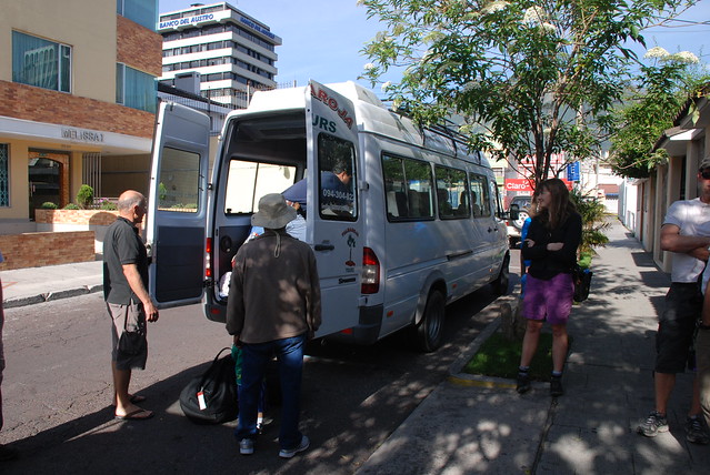
The adventure began by waking up at 4am
and a full day of travel from Seattle to Quijto, eventually crashing at the
Traveler's Inn sometime after midnight. After breakfast those of us who came in
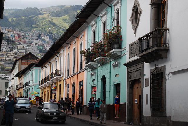
a day early had a chance to get acquainted and explore the city of Quijto.
Day 1: Quijos River Borja Run
Our trip began early Sunday morning when
Larry and Greg Dashper met us at the hotel and loaded up the gang, with the
majority of the paddlers from Portland and the greater Pacific Northwest
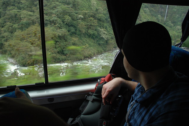
region. The vans carried us up and over the 4100m Papallacta Pass and we
descended through the clouds and into the Amazon basin.
Our van buzzed with anxious anticipation and excitement as we could see challenging whitewater of the Papallacta in the valley below and thus the road scouting began, a wonder our vans didn't tip off the edge of the windy mountain highway as the kayakers all pressed against the window to take in every glimpse of whitewater rapids below.
 |
| Road scouting the Papallacta. |
Arriving at the Lodge—Cabanas Tres Rios at the confluence of the Borja, Cosanga, and Quijos—we enjoyed a great lunch and outfitted our boats. As someone who travels around the country and typically settles for whatever boat is available—from cramming myself into Emily Jackson's little pink boat for a run down the Cheaoh to Eric Nies's big creeker for a run down the Upper Gauley—it was sure nice to have a boat that fit. I can say the collection of boats lived up to the hype of the most modern and complete fleet of boats in Ecuador [note to Harry: did not see a Hydra Duet so a C2 trip may be a challenge].
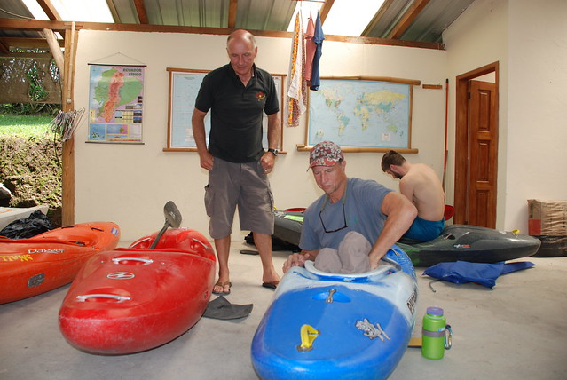 |
| Larry overseas boat outfitting at Cabanas Tres Rios |
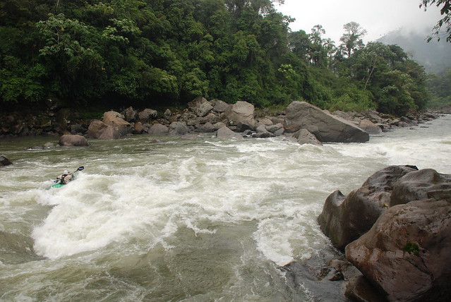
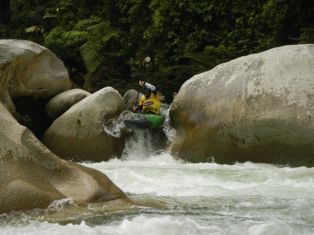
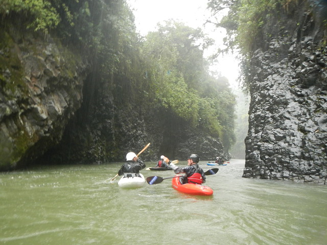
Soon enough it was time to hit the water and our group was led by veteran guide Don Beveridge. We carried our boats down to the put in just steps from the lodge (logistics could not have been more convenient) and several of us peeled out into the first class III rapid on the Quijos. With a couple of holes to avoid it provided a fun and energetic warm up. Others had the option of putting in below as we were cautioned not to take a swim in our first 10 seconds of boating in Ecuador as had happened to one of last week's guests.
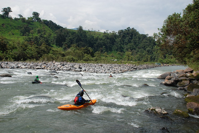 |
| Firing up the first rapid in front of the lodge on the Borja Run. |
Bouncing down the class III run on the Quijos was great fun and a nice way to get to know the other paddlers in our group and dial in our outfitting. Notable rapids included Pika Piedra and Endless Rapid. At the takeout I got to experience one of the newly discovered joys of a guided trip—the drivers were there at the take-out and before we could peel off our wet boating gear the boats were loaded and strapped down.
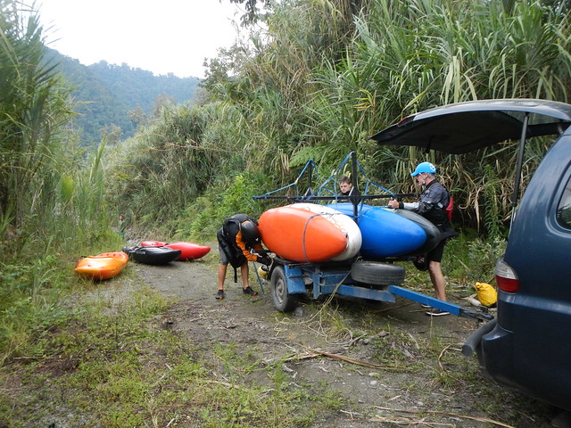 |
| Boats were strapped and loaded before we could finish taking off our drytops. |
Day 2 - Lower Oyacachi and Bombon and Lower Runs on the Quijos
After a pounding rain that rattled our
cabin roof in the pre dawn hours like a steel drum band, we awoke the next
morning to slightly elevated but still moderate river levels. After breakfast
we hopped into the vans, with boats already loaded, and set off downstream in
search of the day's run. Our guides for the day—Don, Greg, Larry, and Guy—settled
on a short stretch of the Lower Oyacachi followed by a run on the Quijos.
 |
| Hiking in to the Oyacachi. |
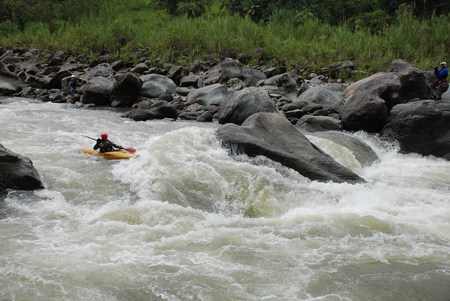
We put in at Ejector Seat, a great class IV rapid to start off the day on a bouncy high volume creek run. Don led us through a fun section of boogie water boulder gardens before we came to another steep class IV drop with a fun line that took us down to the confluence with the Quijos.
 |
| Megi stylin' Ejector Seat on the Oyacachi. |
We continued on down the Bombon section of the Quijos. Notable rapids included "Curvas Peligrosas" an S Turn rapid ending with a basalt wall that marks the entrance to a beautiful gorge. We also ran in formation down "Chuchaqui", a great wave train rapid that became our lunch spot. A couple folks took out at the bridge at Bombon and the rest of us continued on downstream through the first section of the Lower Quijos where we enjoyed "Welcome to the Jungle", "Corner Pocket", and the final rapid, "Gringos Revueltos".
 |
| Don demonstrates the line at Gringos Revueltos with grace and precision. |
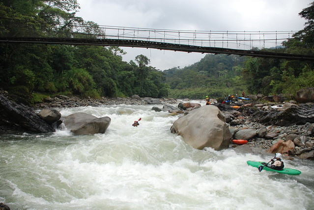
Day 3 - Chaco Canyon of the Quijos River
On our third day we once again enjoyed the
convenience of utilizing the put-in at the lodge and quickly sped down the
class III section we had boated on the first day. On this day however, our real
goal was Chaco Canyon and the big rapid known as El Torro.
The canyon was a spectacular river reach
through beautiful basalt with overhanging jungle and the warm-up
rapids included Basalt and Bitch Slap. The anticipation reached a crescendo
as we pulled out on river left and hopped among the boulders for a view of El
Torro, one of the classic bigwater rapids of the Quijos and the defining
feature of Chaco Canyon. A solid IV+, the line down center right is
surprisingly simple, but plenty of chaotic turbulence on either side can easily
distract one from the preferred line at which point you need to hold on and be
prepared to ride El Torro. As long as you avoid the nasty pour over on far
river left, all ends in a good recovery pool at the bottom right.
 |
| Forget about sneaking the hole. Megi sets up for the big hit at the base of El Torro. |
We split the group below El Torro and I followed Don as he guided us through Olympic Trials, a great series of three tightly spaced rapids that ended at a beautiful gorge at Puente Fucondo that was our take out for the day.
 |
| The beautiful basalt gorge at Puente Fucondo. |
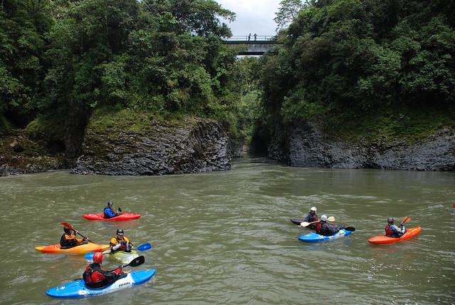
Following our run, we loaded up the vans and headed over the drainage divide into the Napo Valley and made our way to the river town of Tena. A festive vibe filled the air and kayakers from other groups roamed the streets. Like surfers living the Endless Summer, one could quickly tell that kayakers roaming the world in search of good whitewater could find plenty to keep them busy and fulfilled in this historic and friendly river town.
Day 4 - Piatua
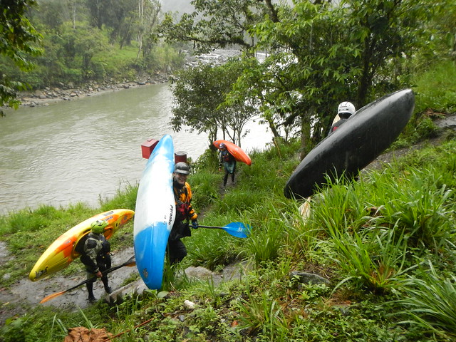
Awakening the fourth day in Tena we
switched to a fleet of taxis—actually yellow pick up trucks that could carry
four boats and paddlers—as we would be venturing up the Piatua and into
territory inaccessible by our vans. For this trip we left as one big group—16
paddlers and 6 guides—in what was likely one of the biggest groups the Piatua
has ever seen. The run is a relatively new whitewater destination with the
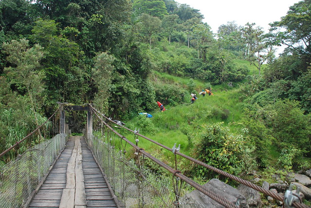
construction of a new road up the valley. As we crossed a sketchy suspension
bridge, one truck at a time, the reason for switching to smaller vehicles
became readily apparent. Just upstream, a massive new bridge was under
construction. While kayakers enjoy improved access to this once inaccessible
run it comes as a mixed blessing for the infrastructure investments are not for
kayakers but rather to accelerate the pace of resource extraction from the
basin—driving up the rutted road we could catch glimpses of a pristine
river but one was left to wonder how long the exceptional water quality
would last.
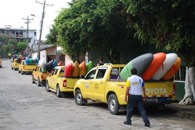 |
| Platoon of Tena taxis loaded and ready to head up the Piatua River Valley. |
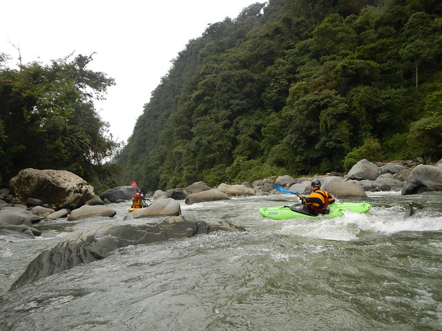
At the river we split into three groups and I had an opportunity to join guides Darcy Gaechter and Liam Kirkham who were leading the group of creekers who had been running slightly more challenging runs through the week. Following Darcy down the Piatua was like following one of the regulars down the Upper Yough as she pointed out every hidden boof ("cheesy boofs" in Darcy parlance), slot move (aka poop chutes), and the best line at rapids like Game Changer, Discotheque, and Disposable Ensign. With several miles of fun boulder gardens, but a rather moderate gradient, the river is a great run for aspiring class IV creekers while guaranteed to keep class V veterans smiling. The Piatua offers a little something for everyone.
 |
| Joey finding one of the many great boofs on the Pitua. |
That evening I sat down with Matt Terry from Ecuadorian Rivers Institute over drinks and pizza as he shared his frustrations and hopes for protecting some of the country's best rivers from development and destruction. While towns like Tena enjoy the benefits of a whitewater industry that may approach $1 million nationwide (at the most generous estimate), it remains but a footnote to the billions of dollars of Chinese investment in infrastructure (hydropower and projects to facilitate resource extraction). So while the country witnesses development in the form of new roads, bridges, rip-rap, dams, the latest Cat heavy machinery—and the incredibly attractive cash flow that comes with all of this—the riparian forest slowly disappears and once pristine rivers become polluted. Monkeys that depend on contiguous patches of forest canopy go the way of the Lorax and fish become a memory. And all of the foreign investment comes with an expectation of repayment in the form of long-term oil contracts at $70/barrel and 7% interest. It's easy to place the blame on the local residents, fueled by greed and an appetite for easy money now, but it's worth reflecting on our own consumerism that fuels our insatiable demand for Chinese products and our role in this ever connected global economy (The Story of Stuff).
Day 5:
While the creekers headed out for a day on
the Upper Jondachi—a run I hope to catch on a future trip someday—the rest of
us hit the Jatunyacu with local guide Tarquino who was proud to show off his
home run. The Jatunyacu is the local rafting run with consistently dependable
flows and great pool-drop class III rapids. We happily enjoyed bouncy wave
trains, some fun surf waves and play boating features, as we danced among the
holes—some giving them a wide berth while others crashed through with reckless
abandon. The memorable rapids included Pimpilala and Land of 1000 Holes.
 |
| Eric enjoying good times on the Jatunyacu. |
It was all smiles at the take-out as we basked in the sunshine and enjoyed our lunch while curious local children investigated our kayaks. Across the river excavators sunk their claws into the earth and scooped up gravel for an unknown construction project.
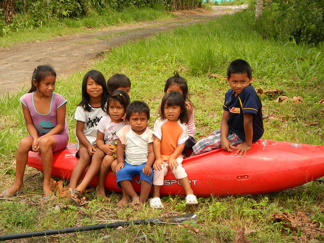 |
| Local kids at the take-out. |
Back in the vans we climbed the switchbacks over the pass and through the cloud forest with a seemingly endless expanse of impenetrable jungle below us. Ultimately descending back into the Quijos Valley we were back at the lodge in time for dinner.
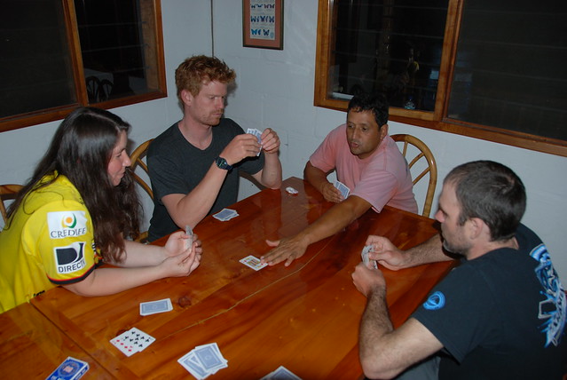 |
| After dinner, a hotly contested game of Cuarenta. |
Day 6: Cosanga
I have always enjoyed following paddlers
down a favorite and treasured local run: Jim Reed on the Miracle Mile, Eric
Nies on the Upper Gauley, Adam Cramer on Great Falls, Dave Steindorf on the
Tobin reach of the Feather. Those trips are always memorable as your local host
takes you on a journey that becomes much more than a river trip as they share a little bit of themselves. So it was on the Lower Cosanga as Larry
took a small group of four of us down a run that is obviously one of his
special places.
 |
| Larry leads us down through Triple Drop on the Cosanga. |
Our van climbed up the Cosanga Valley and dropped us off at a classic Ecuadorian suspension bridge and we gathered in the eddy for a few quick warm up strokes before dropping into a jumbled boulder garden that led into Triple Drop. Flows were low but the run was plenty of fun on this class IV creek and the road quickly disappeared from view as we disappeared into the canyon and deeper into the jungle. We hopped out for a quick scout of Random Acts, one of the steeper boulder gardens that served up a few alternate lines. The rest of the run was all boat scouting and included rapids like Whale Eye, Cock on the Rock, and Ménage Rodeo.
 |
| Megi hits the line at Ménage Rodeo. |
We joined the confluence of the Quijos and pulled out for lunch, a beautiful spot deep in the jungle. From there it was an easy float with fun bouncy class III rapids all the way to the lodge which was our take-out. For me it was another new river (#289 on my life list to be exact), but it was a special day on the water as Larry had the opportunity to introduce me to one of his favorite local runs.
Day 7: Lower Chaco Canyon on the Quijos
The week ended where it began, back on the
Quijos. Once again we were able to pick up a new section on a river that is
truly one of the world's classic whitewater runs. Gary and Larry each led
a pod down as Guy provided sweep. The skies had opened to unleash a downpour but
we were all out to get wet anyway. Unlike my own backyard runs, the Quijos is
warm and pleasant even when it’s raining. Small streams and gullies burst forth
with torrents of muddy water that cascaded down into the canyon where we
launched. Rapids included such classics as Rodeo Star, Two Guys Hugging and
Tetas and everyone had a great run that came to an end all too soon as we
joined the confluence with the Oyacachi and reached our take-out.
 |
| The heavens unleash a downpour as we venture down the Quijos River. |
While some were staying for a few more days or even another week of boating, the trip came to an end for many of us. We enjoyed a final lunch back at the lodge and then began the trek back over the mountains to Quito. With great rivers, good food, and guides that have intimate knowledge of the local runs, the whole trip was a great experience. I hope to get back again some day.
 |
| The end of the trip. |
Participants
Winter Whitewater Class IV-
Eric Bessette, Bellevue, WA
Peter Eisner, Tucson, AZ
Carrie Horner, Portland, OR
Genny Kiley, Barton, OR
Kenny Kiley, Barton, OR
Megi Morishita, Newport, OR
Thomas O'Keefe, Seattle, WA
Kathleen O'Malley, Newport, OR
Maren Vikan, Portland, OR
Advanced Creeking IV+
Brandon Bloomquist, Hillsboro, OR
Shannon Crosswhite, Portland, OR
Alex Dey, Portland, OR
Craig Hermes, Scapoose, OR
Zachery Horner, St. Paul, OR
Joey Thomas, Portland, OR
Michael Williams, Portland, OR
Guides:
Don Beveridge
Josh Brewer-Smith
Greg Dashper
Guy Erb
Darcy Gaechter
Liam Kirkham
Larry Vermeeren
Labels: ecuador, exploration
posted by Thomas O'Keefe @ 10:33 PM
![]()


