Restoration of the Elwha River
Originally Published in the Mountaineers Magazine, July/August 2013
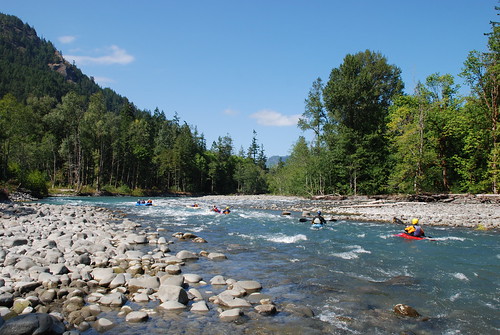
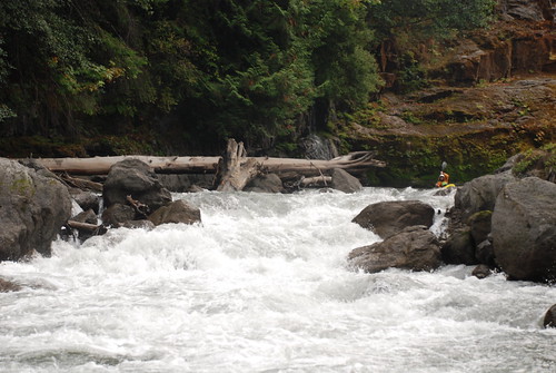
The Elwha River is unique among rivers of the Olympic Peninsula with a watershed that represents approximately 20% of Olympic National Park and headwaters reaching to the very center of Olympic Mountains. These mountains were formed by the domal uplift of marine sedimentary rock and basalt that the powerful Elwha River has carved its way through. The rich geologic diversity that resulted has been sculpted by the action of flowing water, the errosive power of sediment, and the persistent grinding action of the glaciers that have all shaped the landscape. The Elwha River of recent geologic history has all the attributes of river that is well suited for the suite of species that comprise the Pacific salmon, its deep canyons and diverse geology create one of the region’s classic backcountry whitewater destinations, and all the power and volume of a river descending from the mountains to the ocean over a distance of just 40 miles made the river an early candidate for hydropower development.
The Elwha River is unique among rivers of the Olympic Peninsula with a watershed that represents approximately 20% of Olympic National Park and headwaters reaching to the very center of Olympic Mountains. These mountains were formed by the domal uplift of marine sedimentary rock and basalt that the powerful Elwha River has carved its way through. The rich geologic diversity that resulted has been sculpted by the action of flowing water, the errosive power of sediment, and the persistent grinding action of the glaciers that have all shaped the landscape. The Elwha River of recent geologic history has all the attributes of river that is well suited for the suite of species that comprise the Pacific salmon, its deep canyons and diverse geology create one of the region’s classic backcountry whitewater destinations, and all the power and volume of a river descending from the mountains to the ocean over a distance of just 40 miles made the river an early candidate for hydropower development.
The Elwha Dam was not the first dam across the Elwha as the Vashon ice sheet dammed the river forming glacial lake Elwha a little over 10,000 years ago. Beneath the forest canopy the observant hiker can find evidence of glacial terraces, perched deltas, and moraines that provide evidence of the old lake that disappeared with the retreat of the glaciers. As can be observed today in Alaska where glacial retreat has exposed new river habitat, salmon discovered the Elwha and found a rich diversity of habitat. The powerful rapids and cascades of canyon sections of the Elwha exerted strong selection pressure for massive Chinook salmon, pink salmon found ideal habitat in the lower gradient reaches closer to the ocean, and sockeye had access to important rearing habitat in Lake Sutherland. The abundant fishery resource became an important food and cultural resource for the Klallam people, central to the identify of those who called the valley home.

In 1882 the world’s first hydroelectric
project began operation on the Fox River in Wisconsin and with it came ambitous
plans to harness the power of rivers to generate electricity and fuel
industrial development. Thomas Aldwell located a homestead on the Elwha and
slowly began accumulating the land necessary for the development of a hydropower
project over a period of 20 years. Where the Klallam people had found a fishery
resource that sustained their community, Thomas Aldwell looked upon the river
and determined that it was “no longer a wild stream crashing down to the
Strait; the Elwha was peace and power and civilazation.” As Aldwell worked to
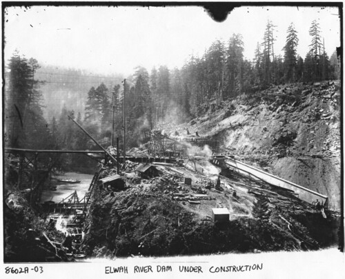
secure the financing, construction of the Elwha dam commenced in 1910. The dam
was not anchored to bedrock but instead set on glacial alluvium—“a dam on
roller skates.” Shortly after construction in October of 1912, the dam failed
in spectacular fashion when the river blew out through the gravel below the
dam. Rebuilding commenced and by the end of 1913 the Elwha was no longer a
free-flowing river as electricity flowed from the powerhouse to Port Angeles
and beyond.
Decommissioning the hydropower projects on
the Elwha was a project that took several decades. By 1927 a second dam had
been constructed at Glines Canyon which was subsequently included within the
boundaries of Olympic National Park. In the mid 1980s as the Federal Energy
Regulatory Commission (FERC) continued to slow walk the license applications
for the two dams, Rick Rutz made the observation that FERC did not have the
jurisdictional authority to license a hydropower dam in a National Park. It
took several years but by 1992 the audacious idea to remove the dams inched
closer to reality with the passage of the Elwha River Ecosystem
and Fisheries Restoration Act. All that
remained was the “small matter” of securing the funding for the project, but by
September 2011 the project was underway as an excavator set to work and began
to break up the concrete and dismantle the dam that Thomas Aldwell had worked
so hard to build. But this dam’s time had passed, and the environmental costs
associated with its continued operation greatly exceeded the small amount of
power it produced. At the official ceremony to mark the occasion, Bureau of
Reclamation Commissioner Mike Conner remarked, “Dam removal is not the best option everywhere but it is the best
option here. and it's the best option in a lot of places because the process
that we are going through these days is we are reassessing the costs and
benefits of certain facilities that exist today… I think this is not only a
historic moment here but it's going to lead to historic moments elsewhere
across the country.”

Today
the Elwha Dam is gone and the river explodes through an impressive rapid in the
heart of the canyon where the dam once blocked its flow. Only 50’ of the 210’
Glines Canyon Dam remains as work continues to completely remove it. Already
salmon have been finding their way upstream of the Elwha Dam site and the river
offers ample opportunities for exploration where one can witness first-hand
what it means to restore a river.
Destinations for a Day Exploring the Elwha
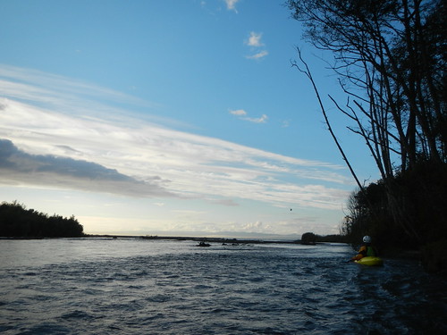
River Mouth
The river mouth is quickly transforming as
the cobble beach transitions to sand as predicted. To explore the new beach
environment head approximately 5 miles west of Port Angeles to Highway 101 mile 242.5 and
take Highway 112 west. Continue on this road for 2.1 miles (crossing the river)
to Place Road. Turn right (north) and follow this road 1.9 miles to the T
junction and then turn right (east) on to Elwha Dike Road and continue 0.1 mile
to the Elwha Dike access point. Day-use parking is available along the road.
Hike a couple hundred yards along the trail towards the ocean.
Elwha Canyon
To see the site of the Elwha Dam site, head
approximately 5 miles west of Port Angeles to Highway 101 mile 242.5 and take Highway 112 west
0.7 mile to the Elwha River. Just before crossing the Elwha bridge turn left
(south) on Lower Dam Road which is
also the turn for Elwha Dam RV Park. The parking area for the trail is to your
immediate left. The first 200 yard section of trail, constructed by Clallam
County, is wheelchair accessible and leads to a partial overlook of the former dam
site. As you approach this first overlook you will see the start of a 1/4 mile
footpath to your left. This trail was built by a Washington Conservation Corps
crew and leads to an overlook that provides the best view of Elwha Canyon and
site of the former dam.

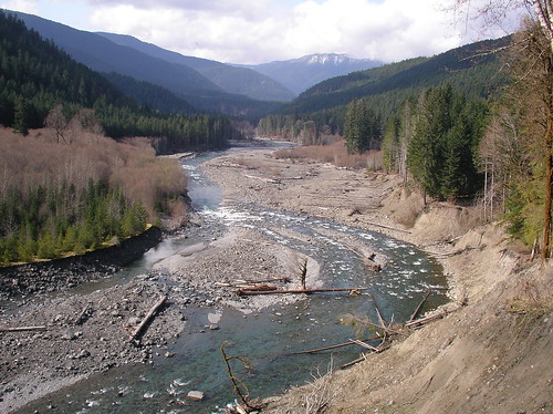
Former Aldwell Reservoir
The former reservoir is a
fascinating landscape of gravels and sand held back by the dam, old stumps with
their springboard notches standing as reminders of the day the riparian forest
was cleared prior to flooding the reservoir, impressive views back up the
valley to the Gates of the Elwha proposed wilderness, a river that is carving
its way through a century of sediment, and evidence of vegetation that is
slowly reclaiming the corridor along the river. To see all this head about 8
miles west of Port Angeles to Highway 101 mile 239.4 just after crossing the
Elwha River bridge. Turn right (north) onto Lake
Aldwell Road towards Olympic Raft and Kayak. Continue on the road 0.2 mile to
the end and the old boat launch that was on the reservoir. From here you can
hike out onto the old reservoir and spend several hours exploring or just a few
minutes.

Former Mills Reservoir and Geyser Valley
While Glines Canyon Dam is still an active
construction site, you can drive up to explore the upper reaches of the former
Mills Reservoir and the backcountry upstream. Head about 8 miles west of Port Angeles to Highway 101 mile 239.5 and turn left (south) onto Olympic Hotsprings Road through
the National Park entrance. Continue 4.0 miles up this road and take the
left-hand turn up to Whiskey Bend. As you proceed up this road you will pass
the Glines Canyon Dam site at mile 1.2, described by members of the 1889 Press
Expedition in colorful prose as an area “rather unsafe for any nervous youths
to travel.” Continuing up the road to mile 4.0, there is a trail that leads
down to the exit from Rica Canyon and the historic start of the Mills Reservoir
(marked with a small sign that reads, "to Lake Mills"). Although the
0.4 mile trail is steep it provides an opportunity to explore the upper end of
the former reservoir and the exit of Rica Canyon. The road ends another 0.4 mile past this trail at the Whiskey
Bend Trailhead. From here it is a 1.2 mile hike to the junction of the Rica
Canyon trail which heads 0.5 miles down to the river and the downstream end of
the Geyser Valley. In contrast to the reaches downstream that are struggling to
digest 34 million cubic yards of sediment, the Geyser Valley is a great place
to see what a floodplain forest would normally look like. It provides an
interesting contrast and a potential future view of what a restored Elwha
forest could look like along the lower reaches someday.
More Photos of the Elwha
Videos:
Altair to the Sea: Kayking Down the Elwha
Going Home: The Salmon Return
Fire in the Hole: Blasting a Dam
More Photos of the Elwha
Videos:
Altair to the Sea: Kayking Down the Elwha
Going Home: The Salmon Return
Fire in the Hole: Blasting a Dam
Labels: conservation, washington
posted by Thomas O'Keefe @ 11:52 PM
![]()
